Session Information
Date: Monday, November 9, 2020
Session Type: Abstract Session
Session Time: 3:00PM-3:50PM
Background/Purpose: Systemic sclerosis (SSc) is a chronic autoimmune sclerosing disease with a 10-year survival rate of less than 65%. This rate has remained unchanged for over 40 years. Although the exact pathogenesis remains unclear, it has been hypothesized that an environmental trigger leads to disease development in a genetically predisposed host. Assessment of high incidence geographic disease clusters can be an initial step in cause identification. ArcGIS is a geospatial processing program used to create and analyze geographic distribution and has recently been utilized to determine high incidence clusters for several cancers and autoimmune diseases. The objectives of this study are to analyze the geographic distribution of SSc in Massachusetts between 1989-2019, determine incidence rates, and evaluate potential environmental exposures.
Methods: Demographic and geographic patient data for SSc cases was obtained from two large, academic tertiary centers in Massachusetts. Incidence rates were calculated per year and per geographic area, based on zip code. Maps were created using ArcMap 10.7.1 to identify case clusters across the state. The SSc incidence maps were compared to maps of environmental exposures to determine potential contribution of pollutants to disease development.
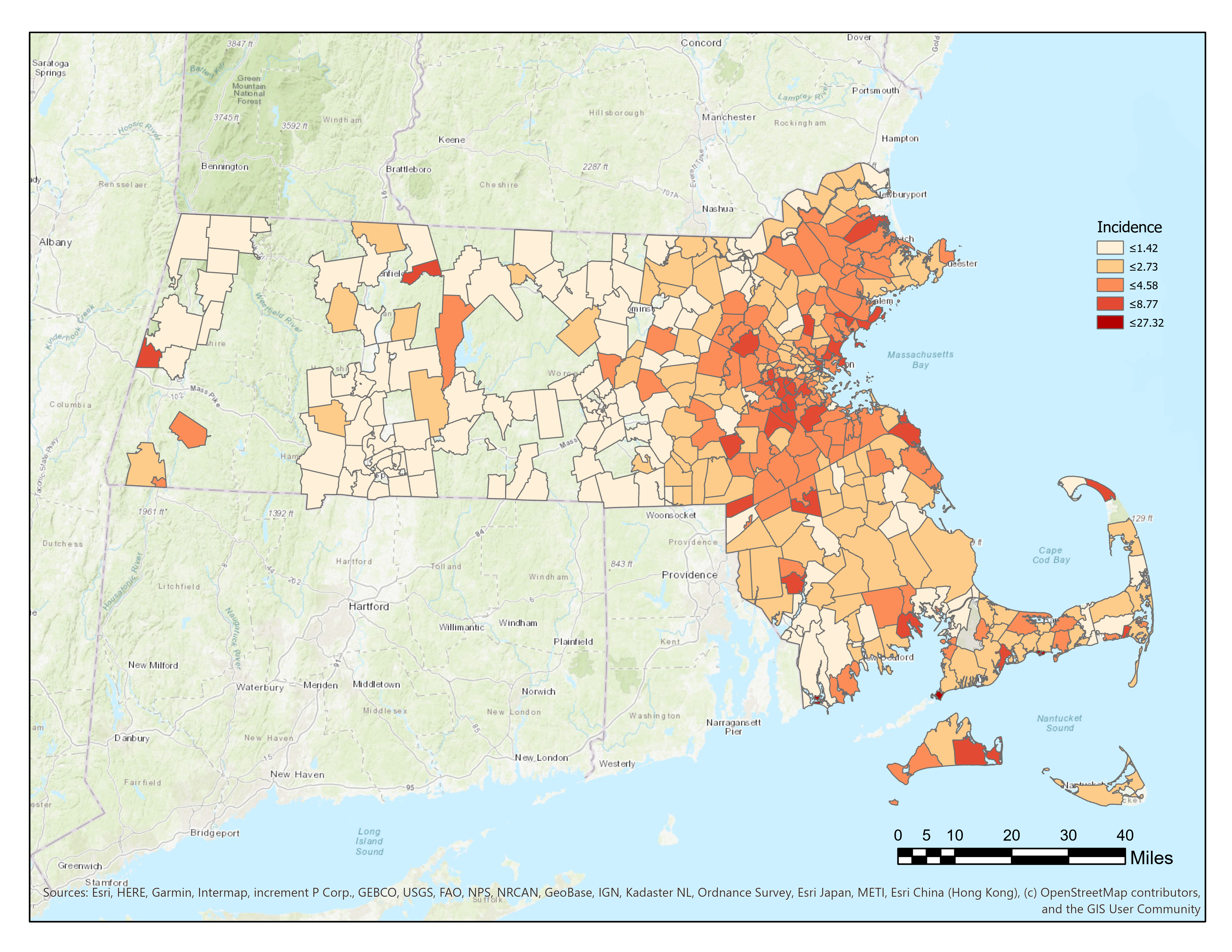
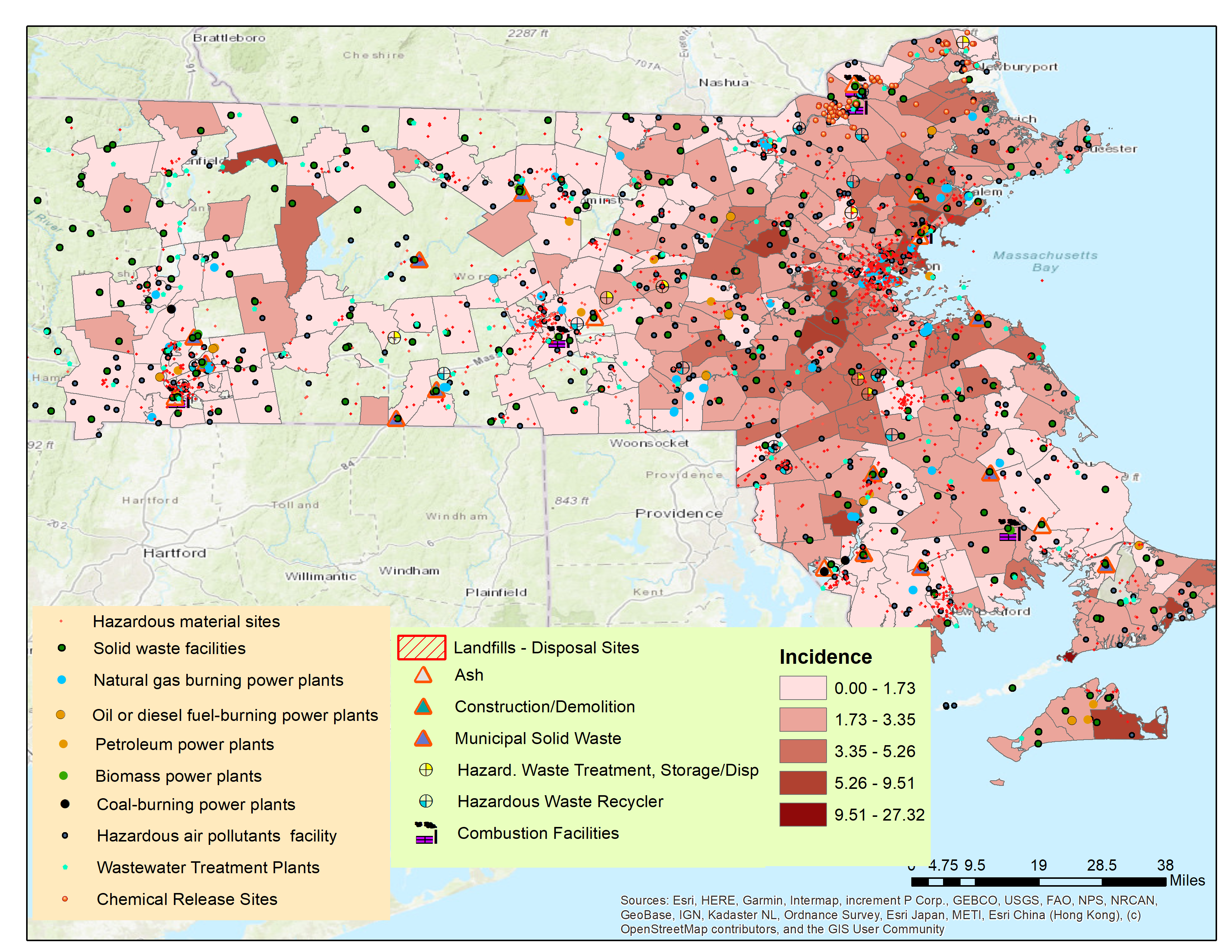
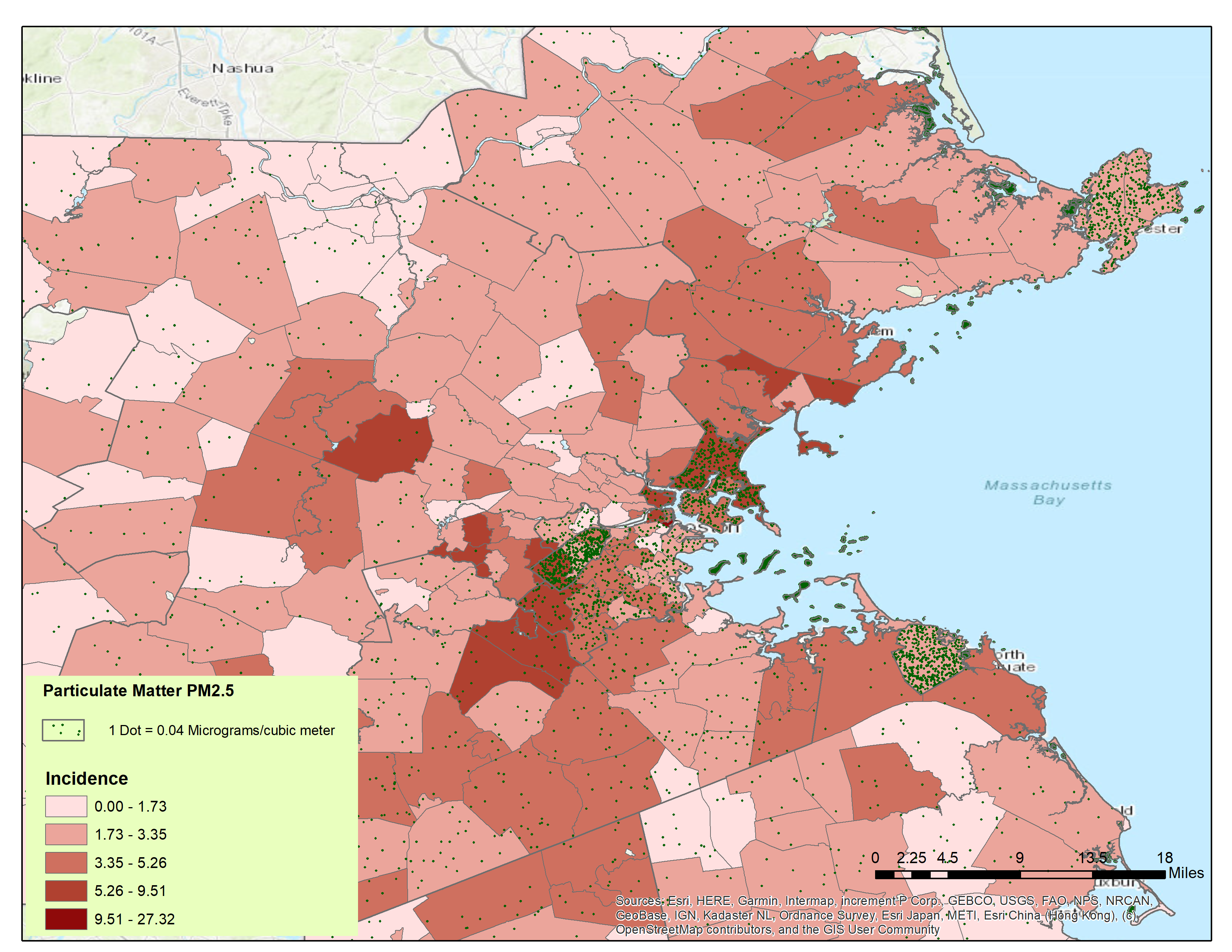
Results: 4,579 patients diagnosed with SSc between 1989-2019 were identified. The crude incidence rate was 24.2 cases per million individuals per year. Geographic analysis revealed increased incidence in specific geographic regions in Massachusetts including Boston, Lynn, Revere, Chelsea, Newton Upper Falls, and Charlestown (Figure 1). The density of industry presence and waste sites was found to be significantly higher in the areas with elevated incidence of SSc compared to low incidence areas (8.5-fold increase; p=0.0087) (Figure 2). Particulate pollution (PM2.5) levels were increased in high incidence areas (Figure 3), and airborne benzene levels correlated well with incidence rates of SSc in the Boston area.
Conclusion: To our knowledge, this is the first study to explore geographic distribution of SSc and evaluate possible triggers for disease development in the United States. The presence of regional clustering and increased density of industry and waste sites in those areas suggests that multiple environmental factors may play a critical role in the development of SSc. Further investigation is warranted to explore these findings.
 Figure 1. Incidence rates per zip code of SSc in Massachusetts
 Figure 2. Industries and waste facilities in Massachusetts
 Figure 3. Particulate pollution levels in relation to SSc incidence in Massachusetts
To cite this abstract in AMA style:
Muntyanu A, Kassamali B, Vleugels R, LaChance A. Geographic Distribution and Environmental Triggers of Systemic Sclerosis in Massachusetts [abstract]. Arthritis Rheumatol. 2020; 72 (suppl 10). https://acrabstracts.org/abstract/geographic-distribution-and-environmental-triggers-of-systemic-sclerosis-in-massachusetts/. Accessed .« Back to ACR Convergence 2020
ACR Meeting Abstracts - https://acrabstracts.org/abstract/geographic-distribution-and-environmental-triggers-of-systemic-sclerosis-in-massachusetts/
